


Simply look around. SLO CAL (San Luis Obispo County) is full of natural wonders hiding in plain sight: a rock so massive the surfers below look like ants. Fairytale lichen dangling from oak branches. A field so white it looks like summer snow. Dunes shifting shape like an ethereal moonscape. These are the SLO CAL sights that make you stop and marvel. Consider this your field guide to the stories behind the scenery.

Chasing wildlife instead? Check out our guides to tidepooling and animal spotting across SLO CAL.

Why Is There a Big Rock Sitting in the Water at Morro Bay?

Back to Top of List
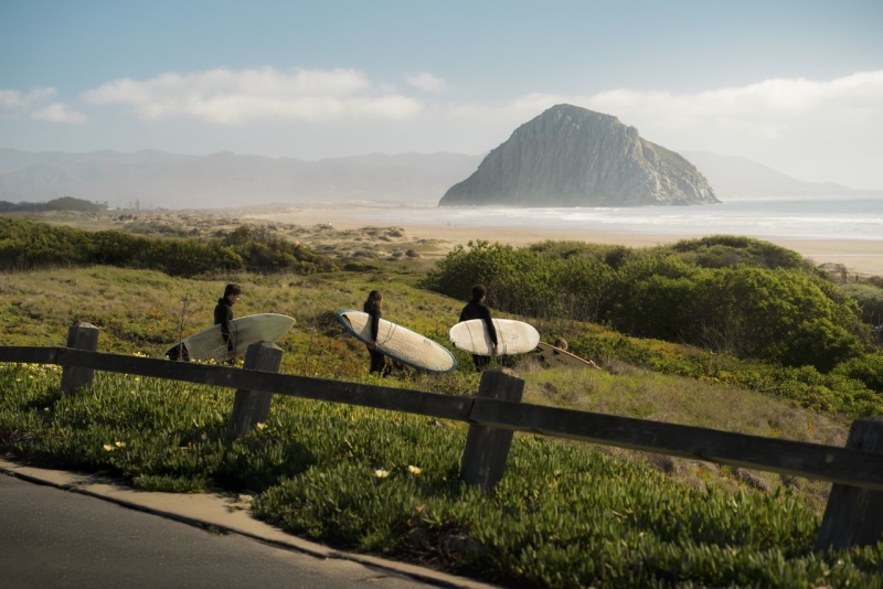
Three surfers with surfboards walking to the water with Morro Rock in the background

What you see: A massive boulder sits in the ocean, visible from miles away along Highway 1, dwarfing the surfers paddling in its shadow far below.

What it is: Morro Rock rises 576 feet straight out of the Pacific and is the remains of a volcano (that's right, a volcano in the ocean). Magma pushed up through the earth's crust about 23 million years ago and hardened underground. Millions of years of erosion wore away the softer rock around it, leaving this solid volcanic core standing at the mouth of the harbor. It was originally a true island, surrounded entirely by water, until the northern channel was filled in to create the harbor you see today.

And Morro Rock isn't alone. It's actually the most famous of SLO CAL's Nine Sisters, a chain of volcanic peaks stretching from Morro Bay to San Luis Obispo.

Where to see it: In Morro Bay, take Coleman Drive to reach Morro Rock's base, where a parking lot sits right at the water's edge. For the full Nine Sisters chain, drive or bike Highway 1 and South Bay Boulevard between Morro Bay and San Luis Obispo, passing Cerro Cabrillo, Hollister Peak, Bishop Peak and Cerro San Luis along the way. Ready to summit one yourself? Cerro San Luis, also known as Madonna Mountain, offers a challenging trail to the top with sweeping views of the surrounding peaks.

Fun fact: The next time you watch a surfer drop into a wave beneath Morro Rock, remember: they’re riding a wave shaped by a volcano older than the Grand Canyon.

Why Does This Valley Look Covered in Snow in July?

Back to Top of List
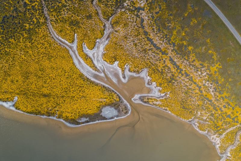
Aerial view of a golden SLO CAL marsh estuary: braided tidal channels weave through bright yellow salt grass, spilling into sandy mudflats. A curvy road traces the top edge—classic California coast scenery.

What you see: Drive out to the Carrizo Plain, tucked into the southeastern interior of SLO CAL, in the middle of summer. What you’ll see there will make you swear your eyes are playing tricks on you: a blinding white flat stretching for acres, looking remarkably like fresh snowfall.

What it is: It’s not snow. It’s salt! Soda Lake sits at the bottom of a closed basin, so water flows in from the surrounding hills with nowhere to flow back out. Rain carries minerals into the lakebed, then the water evaporates, leaving them behind. Repeat that process for thousands of years and you get a salt crust white enough to look like snow from a distance and crunchy enough to hear underfoot.

There’s another surprise nearby. Soda Lake sits almost directly on the San Andreas Fault. At Wallace Creek, the fault has slowly dragged a streambed sideways by more than 400 feet, creating a sharp, unnatural kink where the water should run straight, one of the world's best examples of what geologists call a “fault-offset stream.”

Where to see it: Both stops sit inside Carrizo Plain National Monument, so you can see them on the same trip. Check road conditions before you go, especially after rain, and pack plenty of water. Once you’re out on the plain, it’s mostly open land, salt flats and sky.

Fun fact: Come back in the right spring and the surrounding Temblor Range could be putting on an even bigger show, its slopes blanketed in bright wildflower superblooms, a rare phenomenon when a wet winter lines up with just the right weather conditions.

Are There Really Moonstones at Moonstone Beach?

Back to Top of List

What you see: Walk Moonstone Beach after a storm and, if the light hits just right, you might catch the glow of a pale, translucent stone tucked into the wet sand. Beachcombers flock here to spot the stones that gave this stretch of Cambria coastline its name.

What it is: True moonstones are a type of feldspar. What you’re actually seeing on the beach is most likely chalcedony, a microcrystalline form of quartz with a smooth, glassy appearance. Look along the same stretch of sand and you can also find agate, jasper and jade.

That colorful variety of stones comes from the Franciscan Assemblage, a jumble of ancient seafloor rock scraped up as tectonic plates collided millions of years ago. That collision helps explain why this little stretch of beach can turn up such a surprising mix of storm-tossed treasures.

Where to see it: A boardwalk runs for about a mile above Moonstone Beach, with several stairways leading down to the tide line. Go for a stroll around low tide after a storm for the best chance of spotting rocks glowing in the wet sand. Just remember, since Moonstone Beach sits within Hearst San Simeon State Park, the stones are touch-but-don’t-keep: admire them, photograph them and leave them for the next wanderer to spot.

Fun fact: Keen eyes will also spy frosted pieces of sea glass mixed among the stones, tiny bits of ocean-tumbled history.

Why Is Spanish Moss Hanging From SLO CAL's Oak Trees?

Back to Top of List
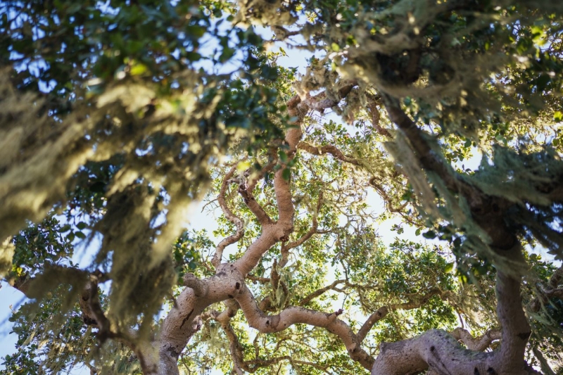
Looking up at a mossy oak canopy with twisting branches and sunlit green leaves in San Luis Obispo County California

What you see: Look up into an oak canopy for a view of pale green to gray-green strands hanging in delicate, lace-like clumps, swaying in the breeze like something out of a storybook.

What it is: Nope, it’s not Spanish moss. In fact, it’s not “moss” at all. What you’re looking at is lace lichen, two organisms sharing one life. A fungus builds the structure while algae tucked inside photosynthesize for both of them. It pulls what it needs from the air, not the tree, so don’t worry. The oak is just lending a branch.

Where to see it: Paso Robles and Atascadero’s oak-lined backroads make for easy spotting, though you’ll find it in coastal groves near Cambria and Morro Bay, too. For a real show, locals point to Huasna Road and Upper Lopez Canyon Road near San Luis Obispo.

Fun fact: Lace lichen is California’s official state lichen and the first lichen any U.S. state has ever named. Lichens are also famously sensitive to air quality, so you can breathe easy knowing that SLO CAL has some of the cleanest air around.

Why Do the Dunes at Oceano Keep Changing Shape?

Back to Top of List
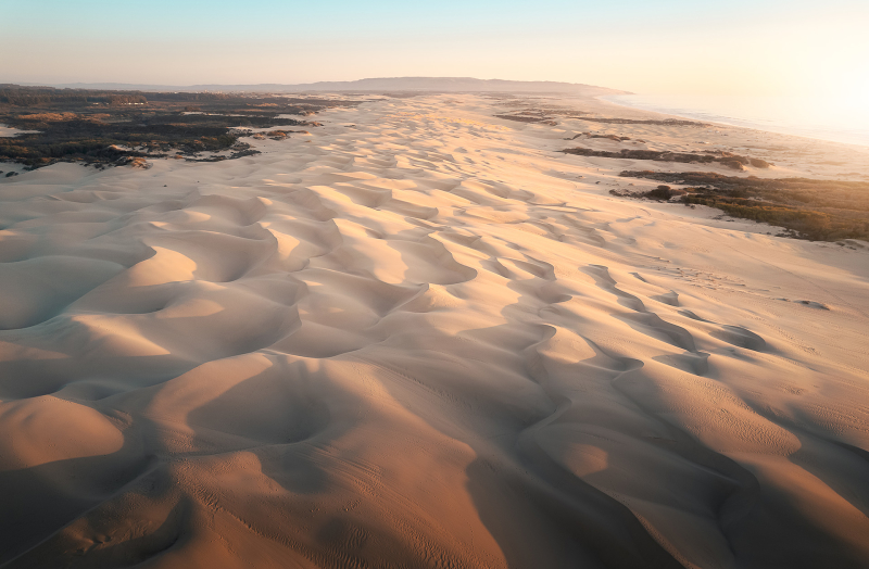
Oceano Dunes Scenic View

What you see: Stand atop a ridge at Oceano and the landscape looks sculpted, with golden waves of sand rolling toward the horizon in smooth, wind-carved curves. It’s hard to believe something this massive is always moving.

What it is: Like sand through an hourglass, this vast dunescape never actually stops shifting. Waves and currents push sediment toward shore, then wind rolls individual grains up each dune until they tip over the crest and slide down the other side. Grain by grain, the dunes slowly shift with the wind.

The dunes are part of the Guadalupe-Nipomo Dunes Complex, an 18-mile stretch of coastline with dunes reaching as high as 500 feet in places.

Where to see it: Explore the open sand at Oceano Dunes State Vehicular Recreation Area on foot or take advantage of its unusual vehicle access. Just be sure to watch for fenced nesting areas set aside for the Western snowy plover.

Fun fact: The dunes hide some incredible Hollywood history. Cecil B. DeMille built a massive set here for the 1923 film The Ten Commandments, then buried it in the sand. The Dunes Center in nearby Guadalupe tells the whole story.

Why Does the Fog Seem to Roll In Like Clockwork?

Back to Top of List
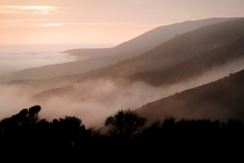
Sunrise over misty coastal hills in San Luis Obispo County with fog rolling through valleys and silhouettes of trees along the ridgeline.

What you see: Spend more than a day or two in SLO CAL and you’ll start to notice a rhythm: gray, soft mornings with fog curling over coastal hills, afternoon sunshine and cool air returning as evening approaches. There’s a reason a light jacket comes in handy around here.

What it is: Yes, it’s the marine layer, as you probably guessed, but it does a lot more than block the morning sun. Cool, moist Pacific air moves inland through coastal valleys and gaps in the hills, influencing SLO CAL’s forests, vineyards and even the way the landscape looks and feels.

That marine influence reaches into the SLO Coast wine region, where fog, ocean breezes and cool air help moderate vineyard temperatures. Pinot Noir and Chardonnay can ripen more slowly while retaining acidity, making that fog over the vines part of what makes this cool-climate wine country award-winning. It does the same for the avocado orchards tucked into SLO CAL’s coastal microclimates, where the same marine cooling keeps the trees from overheating through the growing season.

It changes the view, too. Fog gives morning light a soft, gauzy quality, while its retreat can reveal bright blue skies later in the day.

Where to see it: Walk Fiscalini Ranch Preserve on a foggy morning and you may experience fog drip firsthand, with moisture collecting on Monterey pine needles and falling like a light rain shower.

Fun fact: Fog drip also gives Cambria’s Monterey Pines an extra source of moisture through SLO CAL’s summers.

Why Is This Hillside Rock Blue-Green Instead of Brown?

Back to Top of List

What you see: Hike South Hills Open Space, just a few miles from downtown San Luis Obispo, and the ground starts looking odd: bluish-gray rock poking through the trail, with plants growing sparsely around it.

What it is: This isn’t a sign of anything gone wrong. What you’re seeing is serpentine, and its origins are totally subterranean. California’s official state rock is forced up from deep in the earth’s mantle by the same tectonic collisions that built this coastline. Its unusual chemistry is tough on plant life, heavy in metals and low in nutrients most plants need to thrive. That’s why serpentine outcrops can look sparse and a little alien next to the lush, green hillsides around them.

Where to see it: South Hills offers an easy in-town introduction, with a 1.5-mile hilltop loop that gets you standing on the rock without much effort. For a deeper look, Cuesta Ridge north of town holds a rare forest of Sargent Cypress growing directly out of the serpentine, though reaching it means driving a narrow, winding ridge road.

Why Are Those Oak Trees So Miniature?

Back to Top of List
a bench hidden under the branches of trees in the Elfin Forest in Baywood-Los Osos

What you see: SLO CAL’s back roads showcase a cast of trees: curving eucalyptus leaning over cliffs, towering palms lining hotel driveways and wind-bent cypress clinging to the bluffs. But some of the most interesting trees don’t tower over anything at all. At El Moro Elfin Forest, ancient oaks can stand shorter than the person walking past them.

What it is: These are Coast Live Oaks, the exact same species that can grow 50 feet tall just a few miles inland. But here, salt spray, coastal wind and thin, sandy soil keep them stunted to 4 to 20 feet. They’re ancient, gnarled and, in some cases, barely taller than a person despite centuries of growth.

Where to see it: A mile-long boardwalk loop winds through El Moro Elfin Forest in Los Osos, with entrances at the north ends of 11th through 17th streets and wheelchair access from 16th Street. Just be sure to stick to the boardwalk and marked sand trails.

Fun Fact: Some of these tiny trees have been standing since before California was part of Mexico. Despite looking more like oversized shrubs, individual pygmy oaks here can be estimated at 200 to 400 years old!

Why Do the Rocks at Montaña de Oro Look Tilted, Folded and Stair-Stepped?

Back to Top of List
Coastline view from Montana De Oro

What you see: Hike the bluffs at Montaña de Oro State Park and the cliffs are sure to strike up a sense of wonder. Layers of rock that should sit flat are tipped on their sides, buckled into waves and even folded back on themselves in spots. Higher up, broad, flat benches stack above the surf like a giant’s staircase.

What it is: Both are records of forces you’ve probably never considered. The tilted, folded layers formed as sediment settled on an ancient seafloor, then got squeezed and buckled by millions of years of tectonic pressure. The flat-topped benches above are marine terraces, once part of that same seafloor and lifted step by step out of the water as the coast slowly pushed upward. Each terrace marks a sea level that used to be, now stranded above today’s shoreline.

Where to see it: Montaña de Oro’s Bluff Trail is an easy way to see both at once, following the cliff edge with plenty of opportunities to look down at the rock formations below. Time your visit around low tide if you want to explore farther. The park’s coves are also some of the best places for tidepooling in SLO CAL.

Why Are There Seashells Buried in Wine Country?

Back to Top of List
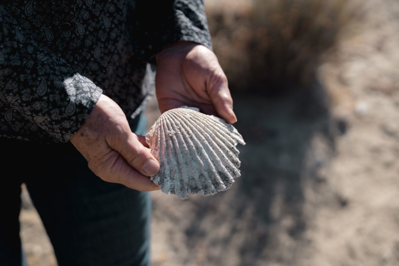

Camatta Ranch, Sustainably SLO CAL, Lazy Arrows Adventures. Woman holding out shell.

What you see: Wine Country holds its secrets, too. Cruise the back roads of western Paso Robles and you’ll pass chalky white rock exposed in road cuts and hillsides between the vines, sometimes with the unmistakable shape of a shell pressed right into the stone. Some Paso Robles wineries have even named vintages and vineyards after this surprising phenomenon.

What it is: That’s limestone, built largely from ancient sea life. Millions of years ago, this stretch of California sat underwater, where shells and skeletons accumulated in layers on the seafloor. Tectonic uplift eventually pushed that ancient ocean floor into the hills you see today, limestone, fossils and all.

It’s also part of the story beneath Paso Robles wine. Calcium-rich soils can drain quickly and influence how vines grow, one reason limestone gets so much love in wine country.

Where to see it: Shell Creek Vineyard in Paso Robles is named for marine fossils exposed along its namesake creek, and Ancient Peaks Winery in Santa Margarita is known for its aptly-named Whalebone Vineyard. You can also spot fossils in exposed rock through the Adelaida, Willow Creek or El Pomar districts.

Fun fact: Next time you’re sipping a glass of Paso Robles wine, consider the millions of years of geologic history sitting underneath the vines.

Take a closer look across SLO CAL

Now that you know the truth about these surprising natural wonders, SLO CAL looks a little different, doesn’t it? That’s the thing about traveling with a little curiosity: the same drive, the same hike, the same glass of wine all become richer once you know the stories hiding in plain sight. Now you can enjoy your own round of Eye Spy, SLO CAL edition. Visit all these hidden natural wonders with the help of this field guide. 

  • Morro Rock and the Nine Sisters — Morro Bay / San Luis Obispo
  • Soda Lake and the San Andreas Fault — Carrizo Plain
  • Moonstones at Moonstone Beach — Cambria
  • Lace lichen on the oaks — Paso Robles, Atascadero, Cambria
  • The moving dunes — Oceano
  • The marine layer and fog drip — Cambria / SLO Coast wine country
  • Serpentine rock — South Hills, San Luis Obispo
  • The miniature oaks of Elfin Forest — Los Osos
  • Tilted rock and marine terraces — Montaña de Oro
  • Fossils in the limestone — Paso Robles wine country